Sunday, September 8, 2013

Skylight, Gray, and Lake Tear of the Clouds

Ever since I heard of Lake Tear of the Clouds I've hoped that I would see it someday. Not only does it have a beautiful name, but it is the highest source of the mighty Hudson River. At 4300 feet Lake Tear is nestled between the giants Marcy, Gray, and Skylight, and requires a round-trip hike of about 16 miles to reach it. I had been pondering my next hike for days, and then on a whim Wednesday morning I decided to buy a new overnight pack and head into the woods to finally see this famous lake and climb the giants around it.

View from Lake Arnold pass
I chose this route as my next adventure because I was unable to find any hiking partners this week, and from what I read both Gray and Skylight don't have any technical rock faces to ascend, so I thought I'd be fairly safe climbing them solo. I set out from the Loj at 3pm, a little later than I planned, toward the Feldspar lean-to about 6 miles in from the Loj. The shortest route to Feldspar was via Lake Arnold, which I had just been to on my way to Colden a few weeks before. I had forgotten how much elevation gain there was to get to the 3800 feet high lake, but fortunately once I got to the lake the next 2 miles were downhill. The trail between Lake Arnold and Feldspar lean-to is one that few people take, which is a shame because it is a gorgeous stretch of trail. The area around Lake Arnold is a lush green forest of balsams, sphagnum moss, ferns, and wildflowers, it almost feels like you're walking through a rain forest. About .3 miles past the lake you come to the top of the pass to an area of blowdown, where over the downed trees you can see mountains 100 miles to the south. In the late day light these distant mountains were glowing in the otherwise grayish landscape, as rain was beginning to fall. After descending the pass to about 3300 feet the trail traverses a series of lush wet meadows, where decrepit bridges make it difficult to keep your feet dry. Many of the bridges sank below the water as I stepped on them, making me grateful for my tall waterproof leather boots. I managed to keep my feet dry, but by the time I reached this point in the trail a steady rain had begun to fall, and the rest of me was starting to get wet. I reached the lean-to at 6pm, a little wet and desperate for shelter, to find that I would have company for the evening. Two other solo hikers, Dan from Buffalo and Dan from Boulder, CO, were already curled up in their sleeping bags watching the rain fall but quickly made room for me to join them. Also in the lean-to was Pia, also from Boulder, a large black mixed breed dog that rivaled many black bears in size, who I knew would keep us and all our food safe (though we all had the required bear-proof canisters a little extra insurance never hurts). After a few hours of conversation about Colorado and the Adirondacks we finally fell asleep to the sound of the rain, which continued until at least midnight. I fell asleep wondering how wet the trails would be in the morning, and whether I'd have to swim across those log bridges to get back to Lake Arnold.

I awoke to a chilly morning but thankfully the rain had stopped and the sun was about to peek over the
Lake Tear of the Clouds
mountains. We were all slow to start, not wanting to leave the warmth of our sleeping bags, but I finally said good-bye to my night companions and set out onto the trail at 8:30. After a restless night of sleep I was moving very slowly up the trail to Lake Tear, which climbed almost instantly from the lean-to, ascending 1000 feet in 1.5 miles. I was relieved to reach the lake, and in awe at how simply beautiful it was with the blue sky reflecting in the still water. I lingered there for a little while, enjoying a second breakfast, before crossing the lake's outlet to begin my ascent of Gray Peak. Gray is one of the "trailless" peaks, but the herd path was fairly easy to follow. Thanks to the rain the trail was very slick in spots, and being on my own I went very slowly to avoid any mishaps. There were two challenging sections of trail--one rock face that it took me a bit to get down but was easy to climb up, and another rock face that I thought was going to defeat me until I saw a herd path around it. Aside from those two sections it was a straight-forward hike to the top, where a large boulder offers a clear view to the northwest, and Marcy and Skylight can be seen over the trees in the other directions. After a short time on the summit I was joined by another solo hiker who nonchalantly exclaimed that Gray is his 46th peak, which was pretty exciting! I wished I had some celebratory champagne, or even a chocolate bar, but all I could offer was my congratulations. I was thankful that he decided to join me in hiking back down the mountain, as the wet trail was a bit precarious to descend. On the way down I had a great look at a lingering Bicknell's Thrush, which I pointed out to my companion and much bird conversation flowed from there. We parted ways at Lake Tear, as he was off to climb back over Marcy and I was off to climb Skylight.

View of Skylight from Gray Peak


Mt Marcy from Skylight
I did Gray first because I wanted to save the best for last that day, and I figured Skylight would be easier. It turned out that Skylight was MUCH easier, and far more spectacular at the top. It took me almost an hour to hike the .5 miles to Gray's summit, but the .5 mile trail to Skylight took me 20 minutes. It was an easy steady walk up a streambed that eventually opens up at the treeline to reveal a beautiful open summit of bare rock and alpine vegetation that offers a 360 degree view that I think rivals any other peak in the Adirondacks. When I reached the top I was exhilarated by the view, by the alpine plants around me, and by the fact that I had this amazingly beautiful place in the world all to myself. At the very top of the peak is a large pile of rocks that were placed there by hikers as part of a tradition that bringing a rock to the summit brings good weather, and I realized I forgot to bring one. I snapped dozens of photos in all directions, taking time to admire so many of the mountains I have already climbed. Marcy looms just to the north, with the distinct summit of Haystack just below it. You can see the entire Great Range, the southern Adirondacks, the McIntyres, the backside of Colden, Giant and Whiteface off in the distance, in fact I wonder if there's a single high peak that can't be seen from Skylight's 4,926 foot summit. The summit itself has a carpet of alpine shrubs and a few patches of Alpine grasses, and enough nooks in the rocks to provide some shelter from the wind. I enjoyed solitude on the summit until I started to lose feeling in my fingers from the cold and wind, and then reluctantly headed back down to begin the 8 mile trek back to the Loj.

The summit of Skylight looking south
After 18 miles of hiking, during 12 of which I had to carry a fully loaded backpack, I was pretty well exhausted for the last few miles of the hike, but ever since my Allen hike my threshold for pain and exhaustion seems to have increased. Plus the exhilaration of finally seeing Lake Tear of the Clouds, of climbing the tricky spots on Gray, and enjoying solitude on Skylight, was completely worth being tired and sore. Hiking alone was a nice change of pace, there's something so calming about hiking so many miles without seeing another soul, you become much more in tune with what's around you. I couldn't help but think that my hike couldn't have worked out more perfectly, as I found kind companions for the parts of the hike that scared me the most--sleeping alone in the dark and descending Gray's slippery rocks--yet was able to enjoy solitude the rest of the time. As I reflected on my journey I decided it was the best day of hiking I'd ever had, and that Skylight had risen to the top of my list as my new favorite mountain.

A panoramic view from Skylight looking north

Sunday, August 25, 2013

Allen Mountain-A Rite of Passage

With a hike of over 16 miles I feel like Allen Mountain is like a right of passage for an aspiring 46er. Once you've climbed Allen, there's really no reason to turn back. I've heard many things over the years about Allen, most of them intimidating. Mostly I've heard about the river crossings that can all be a challenge in wet seasons, and I'd also heard about some infamous red slime that makes ascending the bare rock sections of the trail a little perilous. And of course I knew that the distance alone, 16.2 miles, was not an easy feat for a single day, and that such a distance usually requires hiking in the dark in at least one direction. Because of that it's not easy to find someone who is willing to hike Allen just for fun, they have to be looking to check  it off their list. So when a friend of mine asked if I wanted to join her and another aspiring 46er on a hike to Allen, I figured I should take the chance despite knowing that it would be the hardest thing I've done so far.

Allen Mtn. itself isn't much of a giant, at 4340 feet it is only the 26th highest peak, but what makes it so challenging is the lack of easy access, which means a 6 mile hike into the base of the mountain. From there the trail eases into a moderate grade for the next mile or so, and then the final mile is a steep, slippery slope to the top that is made all the more difficult by the fact that you've already been hiking for 3-4 hours. The round trip hike can take anywhere from 10-14 hours depending on one's ability, so an early start is essential. A late start was our first mistake of the day, as some miscommunication due to poor cell phone reception caused us to start an hour later than we had planned, at 8:30am. We knew we were going to have to keep a strong pace all day if we wanted to be back to the car before dark, which meant walking quickly, taking only short breaks for food and water, and no naps on the summit--it was going to be a rough day for me. After only about 5 minutes on the trail we came to the first river crossing, over a narrow stretch of the headwaters of the Hudson. Fortunately a dry August meant the water level was low enough to cross fairly easily, though we did take our shoes off to do it. Ten minutes later we reached another crossing, over what looked like a slow moving river but what is actually a small lake, and made our second mistake of the day. I had read that the bridge over Lake Jimmy was out but that a new trail had been made around it, but didn't realize that Lake Jimmy was so close to the start of the trail. The old bridge was mostly intact except for the first two stretches of bridge, so we chose to wade through the mucky water to take the bridge across. The first person to go became the guinea pig, and when she sunk up to her waist in water the next person across found an easier route. With my pants rolled as high as they could go I managed to get just the bottoms wet, and was thankful that I at least managed to keep my underwear dry--for now.

Due to our grueling pace and pouring rain this
is the only photo I took on our hike as we
descended the streambed
After the lake the trail follows an old road for a while, where raspberries and blackberries made excellent snacks. The trail eventually becomes more heavily wooded and a soft carpet of dirt and leaf litter make for easy walking. The Opalescent, a gorgeous river on every stretch I've seen it, was easily crossed but I could see it being a challenge in other seasons. After 6.5 miles the trail comes to a nice cascading waterfall, and from there the real climbing begins. Like may herd paths the trail meanders around a brook, which means a steep, rocky, and wet trail. We quickly found ourselves combating the infamous red slime, which made the rocks extremely slick even at the slightest grade.This and other challenges makes the climb up the last 1.5 miles very slow going. We had been hiking at a little over 2 miles an hour to that point, but it took us another 2 hours to make the final "ascent". Why the quotation marks? Well, our third mistake of the day was following the stream all the way to the top, even though we knew by our maps that the trail should veer to the left from the streambed at some point. We were definitely not the first people to make this mistake, as we were clearly following a trail, but it was not the right trail. We realized this was probably the case when the balsams started to close in around us, as my gut was telling me that with thousands of 46ers even a herd path should be much more distinct. So why did we continue on? That had something to do with the rumbles of thunder that were starting to get closer and closer as we neared the top, and we figured at the very least we would come out near the summit and the trail we were on would still guide us to it. We came out to a summit that was concealed by trees, and spent a long time convincing ourselves that we were on the summit, even though we could see a higher summit a short distance away. As we debated our true location the thunder got closer and the wind was starting to rip through the trees, so we knew that trying to bushwhack to the true summit wasn't possible, that we needed to get off the "top" of the mountain. As we hurried down the herdpath we started to hear voices to our right, and when we got to an open rock slide we ran into three guys who had just come down from the real summit. Conveniently we met them at the exact spot where we had gone astray, where the trail veers left from the slide. I was very disappointed to see that there was no cairn or any other marker at this crucial turn, which is why we so easily missed it. At this point the rain was starting to fall, and the thunderstorm was just about over us. Of the three guys one told us that the summit was only 20 minutes away and we should get it while we're here, one gave us a sympathetic look, and the other told us that our lives were more important than reaching a summit in a thunderstorm. For one of the people I was hiking with Allen was her 43rd peak, and she had plans to finish the 46 with family and friends on Porter next week, so she needed that peak. So we all started up the slide, but when it started downpouring and we passed a nice rocky overhang that could keep us dry two of us decided to seek refuge while she raced up to the top. She made it, and good for her. As for me, it looks like I'll be climbing Allen again someday.

Our hike back definitely ranks as my most miserable descent of a mountain, as the rain continued for at least another hour until every inch of our bodies were soaked. The rocky streambed that was partially dry on the way up had become a roaring stream. The same dry footholds we had used on the way up became small waterfalls on the way down. My pants were soaked and chaffing my skin. My shoes squished every time I took a step. I changed my socks once, which stopped the squishing for a bit but when you're exhausted it is nearly impossible to keep your feet dry for long because you just don't care about going around the puddles anymore. One the way back we only took 2 breaks in 8 miles--once at the waterfall and once at the trail register that is about halfway. Other than that we walked the fastest pace we could, which for me was a little slower than my companions. My body ached more than it ever has, and three days later I can still feel the effects of Allen. We made it back to the car just as the forest was growing too dark to see, at around 8:00pm, after 11.5 hours of hiking. We all changed into dry clothes and had a much-deserved celebratory beer in the parking lot, because despite how wet, tired, and incredibly sore I was, despite the fact that I hadn't even made it to the top, I felt like celebrating simply because I survived. What we did was just as hard as making the summit, maybe harder since we had to bushwhack, and I felt that I had made the rite of passage anyway. I was more exhausted than I've ever been, but I still felt exhilarated by what we had done. And I had learned many important lessons that day, so that the next time I climb Allen Mtn., I'll be ready. Allen Mtn., we will meet again, but next time it will be an overnight trip on a clear sunny day.

Tuesday, August 20, 2013

Traversing Through the Alpine from Algonquin to Iroquois

The first time I climbed Algonquin was back in 2007, nearly five years ago when I first started hiking the high peaks. I was very much looking forward to exploring the broad summit, soaking in the views of more than 100 peaks, but the weather had other ideas. Although it was a fairly warm day at the bottom, at the top the winds were so fierce that I had to hold onto all by belongings to keep them from flying off the mountain, and even had to brace myself to keep from falling over. I stayed on the summit just long enough to snap some pictures and then descended to the Wright trail junction to eat and log the hike into my journal. But I always knew I would return to the mountain someday in a quest to climb Iroquois, for the which the shortest route is to take the trail from the Loj to Algonquin and continue onto Boundary and Iroquois. I made sure I waited for a better day this time so that I could enjoy the summit, and the weather turned out to be absolutely perfect.

Alpine grasses and sedges  create lush meadows
The main reason I was looking so forward to climbing Algonquin is because its height (the second highest at 5,114 feet) and broad summit make it the perfect habitat for alpine species of plants. Many of the Adirondack high peaks have plants that are found only in alpine habitats, but none of them have as much alpine vegetation as Algonquin. There are only 85 acres of alpine habitat in the Adirondacks, and more than half of that is found on the McIntyre range, which is the collective term for the ridgeline that is composed of Algonquin, Boundary, and Iroquois peaks. The trail to Algonquin from the Loj is only 3.6 miles, but  with an ascent of nearly 3,000 feet it is a very steep, relentlessly rocky hike to the summit. A few hundred feet below the summit the trees give way to open rock and the largest alpine meadow I've seen in the Adirondacks. It looks like a sea of grass (sedge actually), the way the Deer's Hair Sedge flows in the wind. Upon closer inspection one can find alpine species of wildflowers, lichens, and shrubs. On one part of the summit a puddle of water nestled in the sedge meadow made a beautiful foreground for photos of the surrounding peaks. Algonquin is a very popular trail, we probably saw a couple dozen other hikers just in the time that we spent on the summit, but there is room on the summit for everyone to have their own space. To protect the fragile alpine vegetation from so many hikers small rocks have been put in place to keep people on the bare rock, and furthermore a summit steward is present to educate people on the importance of preserving the rare alpine plants. Alpine plants need to have very shallow root systems in order to grow in such a thin layer of soil, which makes them very vulnerable to the pressure of people's footsteps. Heavy traffic in the 1970's ruined a great deal of alpine vegetation in the Adirondacks, but conservation and education efforts to keep people off the soil have been effective in restoring the alpine character of the Adirondack high peaks so that people like me can enjoy it today.

The alpine ecosystem of Algonquin's summit


Boundary and Iroquois from Algonquin
This McIntyre range is one of the most distinctive ridgelines in the Adirondacks, as thousands of people glance at it each day as they pass the Loj Road on route 73. I look at it almost every day, and can't count the number of sunrises and sunsets I've seen painting the ridge in color. Just last week I had a closer view of it from the summit of Colden, which is separated from the McIntyre Range by the steep walls of Avalanche Pass. From Colden the traverse from Algonquin to Boundary and Iroquois, so named because Boundary
was once the landmark that separated hunting grounds between the Algonquin and Iroquois tribes, looked like it would be an easy one. It looks like there is minimal elevation gain between the two peaks, as you simply descend Algonquin, hike over the small bump that is Boundary, and then scramble up a few hundred feet to the summit of Iroquois. What you don't see from the summit of Colden is the two steep sections of bare rock that you have to climb hand-over-foot in order to reach the summit. The walk over the ridgeline is very pleasant, the trail is so narrow that you feel as though you're being embraced by the balsam fir, and you have to brush up against other people to pass them on the trail. A new series of wooden planks, just built this year, carries you over the muddy sections of the cols between the peaks, and gives your feet respite from the rocks and mud. You break out of the balsams for just a moment to reach the bare rock bump of boundary, then dip back down into them to make your way toward Iroquois. The last tenth of a mile to Iroquois is more challenging than I expected, and the last ten feet is the worst. There is one large rock at the edge of the summit, the last step before the destination, that I had a tough time mustering up the courage to leap up, but fortunately was saved by a nice person on the summit that came to give us a hand. The summit of Iroquois doesn't have glorious alpine meadows like Algonquin, but it does have peace and quiet, as only a handful of people that climb Algonquin continue onto Iroquois. The view is just as amazing, looking down at Lake Colden and Flowed lands, and peering further to the peaks of the south and west than Algonquin. We didn't stay long, though, because we knew the hardest part of the hike was yet to come.

View from Algonquin to the west

Hiking down from Iroquois was a mental challenge, and hiking back up over the summit of Algonquin was a physical challenge. That was the first point in the day where my legs just refused to keep going, and we had to rest a few times while making that last ascent to Algonquin's summit. Once we reached the top we collapsed and stayed to enjoy the summit for a long time. The weather was mostly sunny with only a light breeze, which is an uncommonly perfect day to be on Algonquin. I stripped off my shoes and socks, ditched the windbreaker, and laid my head back on my pack to relax. For a while I just laid there watching the Deer's Hair Sedge flow with the breeze, gazing at the striking slides of Colden beyond. I didn't ever want to leave, but I knew it wouldn't stay 70 and sunny for too much longer. The hike back seemed longer than the hike in, and took us just as much time, almost 3 hours. Navigating the rocky terrain of Algonquin's trail for the next 2.5 miles was very slow going, and even as slow as we were going my hiking partner slipped a few times. We were relieved to finally reach the main trail back to the Loj, relishing the soft dirt for the past mile. We were completely exhausted, but exhilarated to have completed the hike.

View from Algonquin to the east, with Mt. Colden prominent in the center
Algonquin's alpine summit
As I hiked I couldn't help thinking about what life was like in the time of the tribes that those two peaks are named for, how much more difficult it must have been to climb those peaks before trails. Did they take the same route that we had taken, or did they know an easier way? So many of the Adirondack mountains had been named by the tribes but were later renamed for famous settlers and explorers. I think Tahawus, meaning "cloudsplitter" is a much better name than Mt. Marcy and wish it had stayed that way. It's little consolation that people had the sense to at least recognize the significance of the peaks to native tribes by choosing to name two of the giants "Algonquin" and "Iroquois", but at least in doing so they've retained a small part of the region's pre-settlement history. I wonder how often the native tribes climbed such mountains, whether they did so to hunt game and gather fruit, like the cranberries I saw growing on Boundary, or if they, like me, just climbed it for sheer enjoyment, to gaze at all the peaks below and remind themselves of how magnificent the Adirondacks truly are.


Monday, August 12, 2013

Hiking Solo to Mount Colden

It's been a while since I hiked a high peak on my own, as I've been fortunate enough to make a lot of hiking friends in the past year, but sometimes the weather is just too perfect to wait for those friends to have a day off. While I enjoy the solitude of hiking on smaller mountains, I prefer company on the bigger ones for three reasons. One, safety in numbers in case an accident should happen. Two,the distraction of conversation to keep my mind off of how sore my feet are after ten plus miles. Third, a helping hand to get past the tricky spots on the trail, those spots where your next step looks like an impenetrable wall of rock with no hand or foot holds, and it takes teamwork to figure out how to get past it. It seems almost every high peak has at least one of those spots, as if mother nature herself put it there to weed out the people like me who actually fear falling and breaking something. But I really wanted to hike something this weekend, and after talking to people and reading trip reports it sounded like Mount Colden was a fairly safe and straight-forward hike up the Lake Arnold trail, making it a good candidate for a solo hike.

Closed Gentian, so named because it never opens
I expected the 11th highest peak in the Adirondacks, with it's steep slides looming over Avalanche Lake, to be a challenging hike that I would barely make it back from. The hike itself from the Loj is about 13 miles and has 2900 feet of elevation gain, certainly nothing to shake a stick at. So I was pleasantly surprised to find myself keeping a good pace all the way to the top, with just a few rests to refuel along the way. One of those rests was at Lake Arnold, which is really a small boggy pond, at 3,772 feet, a quaint body of water with dragonflies buzzing about. One of my favorite late-summer wildflowers, Closed Gentian, was blooming along the shore. The trail from the Loj to the lake is a nice, gradual climb that winds back and forth across a brook. From the lake it is only 1.4 more miles to the top, though it is certainly the steepest and muddiest section of the entire trail. The trail rises steadily from the lakeshore to top out at bald summit that looks like it could be the end, except for the fact that the real summit is clearly looming over it another .25 miles away. Although this false summit is not the destination, it has a spectacular view in all directions and warrants taking a breather. I stopped here on my way up and my way back, as it was a little warmer and less windy than the true summit and made a better spot to relax. The descent from the false summit to the col between the summit is the steepest part of the hike, with a few tricky spots, one of which was a challenge to climb back up (which is exactly the type pf spot I was referencing in my first paragraph!). The trail dips down and over a small bump, and then makes a quick steep climb to the true summit.

Lake Arnold


McIntryre range and Avalanche Lake at the bottom
Lake Colden from the summit
The summit itself is broad and by wandering around it you can get a spectacular 360 degree view of the Adirondacks, with almost every other high peak in view. What is even more spectacular is the view of all the bodies of water below. You can look straight down to Avalanche Lake and see the wooden planks that guide hikers along the sheer rock walls. From the far end of the summit you can see Lake Colden, Colden dam, and the Flowed Lands. In the far distance you can see Lake Placid, including the town itself with Whiteface looming beyond it. Look the other way and Mt. Marcy is looming over you, along with all the peaks around it. I could recognize Cascade and the patchwork of rock that is Pitchoff just over the hill of the false summit.  Obviously I had a clear day, with blue sky and fluffy clouds, so it seemed like I could see forever. It was a perfect day for hiking, just cool enough to keep from overheating, though that meant staying on the windy summit required a few layers to keep warm. I ate my lunch and rested a bit on the summit, then made my way down to the first summit to take a little nap out of the wind. Then I reluctantly headed back.

Indian Pipe
The hike back was fairly easy with the exception of that one tricky spot that I spent a few minutes trying to find a way up before a nice person coming down the trail offered me a hand. The hike down was fairly uneventful, as the birds were quiet and there weren't many people coming up the trail that time of day. My only highlight coming down was a nice patch of Indian Pipe nestled between some Bunchberry, making a nice photograph. The trail was very wet after Friday's rains and by the time I got back to the Loj I was a muddy and sweaty mess. But I was happy to find that I wasn't completely exhausted, like I usually am after long hikes, which was nice. It seems I've finally gotten my hiking muscles in good enough shape to enjoy these hikes without suffering the long way back. Looks like I'm ready to climb some more....
Mt. Marcy and endless other peaks

The McIntrye Range and steep walls of Avalanche Lake

Saturday, July 13, 2013

An unexpected hike up Saddleback Mountain

Johns Brook
It's been a rough summer for people like me in the Adirondacks, who would normally be hiking at every chance, as the rain has put a halt on a lot of summer activities. I work early mornings, so I usually get out off work just in time for the afternoon thunderstorms to roll in. So when we finally had a day without rain, and then another, and the short-term forecast showed dry weather and low humidity for the next few days I had to jump at the chance to hike. A coworker of mine was planning to hike into Johns Brook to hike the Great Range, and invited me and another coworker along. Neither of us are in shape to hike the entire Great Range in one day, and peak-bagging isn't quite my style, but we decided it would be fun to hike in and camp together and then hike a peak or two on our own the next day. So on Thursday evening we set out for the interior outpost at Johns Brook, with the intention of getting up early to hike the Wolfjaws the next day.


Orebed Brook
Very long staircase up the slide


We woke up at 6am as planned, but the rest of the day did not follow the plan at all. At 6:30am we set out from the interior outpost and crossed Johns Brook on an impressive and fun suspension bridge to reach the Range Trail. The Range Trail begins a slow but steady ascent from Johns Brook and stays at this pace for the next 1-2 miles, passing scenic brooks and waterfalls along the way. After about an hour we came to a lean-to, which I assumed was the Wolfjaw lean-to, and figured we had another .9 miles to the trail junction between Upper and Lower Wolfjaw. Well, shortly after that the trail began to climb more steadily and after hiking a bit we came out to an open slide with impressive piles of debris from hurricane Irene. Around this time we heard our first Bicknell's Thrush of the day, as well as the high pitched call of Blackpoll Warblers, indicating that we were well above 3000 feet. As we scrambled over open rock and fallen trees we started to wonder if we were on the right trail, as I hadn't read about any open slides on the way to the Wolfjaws. About halfway up the slide we came to an extremely long set of ladders to help ascend the remainder of the slide, and at the base of them was a sign indicating that we were at 3500 feet. I puled out my map and noted that the junction for Upper and Lower Wolfjaw should have been at 3400 feet, and started to wonder how we could have missed it. When we reached the top of the last ladder and there still was no junction we started to realize that we were weren't climbing the mountain that we thought we were climbing, but we were certainly climbing something so we might as well go on. After the slide the trail became relentlessly steep, with numerous rocky pitches to climb and many wet rocks and roots to navigate. When we came to a sign indicating that we were at 4000 feet we just laughed, because we still had no idea which mountain we were climbing, which added a fun element of adventure to the whole hike. But shortly after that sign we finally reached a trail junction indicating that Gothics was .6 miles one way and Saddleback was .5 miles the other way. I pulled out my map and realized that we had missed the turn for the Wolfjaw trail many miles ago and had been on the Orebed trail the entire time! We laughed about that for a while and then continued on to the summit of Saddleback Mountain, which would also be a new peak for all of us. The last .5 miles was steep and tricky in spots but we made it to the top and were treated to gorgeous views Gothics, Marcy, the McIntyre range, and the eastern high peaks with the Ausable lakes below in the distance. It was a perfect day of blue sky, few clouds, low humidity, and cooler temperatures, and it was only 10am so we could stay a while and enjoy it.


View from the summit of Saddleback Mountain, with Gothics in the foreground, Marcy just behind it, the McIntyre range on the right, and eastern high peaks on the left
I'm actually really glad that we climbed Saddleback by accident, as it is a really impressive peak and was on my list to do in the near future. Most consider Saddleback to be the most difficult of all the high peaks to ascend, so we were quite proud of ourselves for climbing it. The most difficult part of the trail is actually on the west side, which we avoided by ascending from the east, but the east trail certainly had its challenges as well. Most hikers continue over Saddleback to Basin, which requires descending Saddleback on a series of steep ledges which are dangerous and more difficult to climb than any other trail in the high peaks. I'm not a thrill seeker and vowed a long time ago to avoid that section by hiking the peaks separately, so I will return to Basin someday from the opposite side. Unlike most hikers we descended Saddleback the way we came, surprisingly without any accidents, at a much faster pace than we expected. On our way back we were able to figure out where we went wrong when we reached the junction for the Range, Wolfjaw, and Johns Brook trail and saw that the sign for the wolfjaws was facing away from the direction at which we had come from the outpost. A simple mistake that changed our entire day, but fortunately it changed it for the better. And now that I know the right way to go, I suspect that the wolfjaws will be my next adventure, if this warm dry air sticks around for a while!
View from the lower summit of Saddleback Mtn

Thursday, July 4, 2013

Whitney Wilderness Area

Despite the forecast for scattered thunderstorms that has plagued the Adirondacks for weeks now I decided it was time to get out into the woods anyway this past weekend. I had a friend visiting the Adirondacks for the first time so I needed a place that would showcase just how beautiful and amazing this place can be, a place that feels like true wilderness. For that I chose to spend the weekend on Lake Lila, in the William C. Whitney wilderness area between Tupper Lake and Long Lake, and it turned out to be a perfect choice.

Lake Lila in the Whitney wilderness area
The Whitney wilderness area encompasses a number of lakes and ponds that allow non-motorized boats only and provide access to some of the most remote areas of the park. The three main bodies of water that paddlers use are Round Lake, Little Tupper Lake, and Lake Lila, each of which has a number of first-come first-serve backcountry campsites along their shores. Adventurous paddlers could paddle all three lakes via connecting streams or portages, as well as a few smaller ponds. Each of the three lakes is accessed by Sabattis Road, which happens to be an excellent birding spot. Sabattis Road passes through boreal habitat and stopping along the road can produce Black-backed woodpeckers, Palm Warblers, and Lincoln's Sparrows. The outlet of Little Tupper Lake has an excellent diversity of wetland birds and can also be a good spot to see otters. The first parking area one approaches is the put in for Round Lake, which is accessed by paddling a mile up a wide, slow-moving river that connects Round Lake and Little Tupper. This short paddle also goes through lovely boreal habitat and can be a good place for uncommon wetland species and is one of the few places I've seen breeding Ring-necked Ducks. Round Lake is a small lake with a few islands, about a dozen campsites, and at least one pair of nesting loons, making it perfect for a day long paddle or a short camping trip.


Dawn on Lake Lila
Little Tupper is a much larger lake, 6 miles long, with minimal development along the shores. The boat launch is located next to a cluster of DEC buildings which are inhabited by Americorps trail crews each summer. A few private residences owned by the Whitney family are also located on Little Tupper. I haven't had the chance to explore this lake much beyond the boat launch area, but by its size it seems like the perfect place for an extended camping trip. Those seeking a sense of true wilderness usually continue further down Sabattis Road to the access road for Lake Lila, which is a 4.5 mile slow-going drive to the parking area. When I arrived at the parking area on Saturday morning I was shocked to find the lot almost completely full--there was barely enough space to park my little hatchback. This of course led me to fear that there wouldn't be any open campsites on the lake, but fortunately a ranger was present to inform us that there were plenty of sites left. The small lot provides parking not only for Lake Lila, but also for hiking Mt. Frederica, or paddling on to other connected lakes, so a full lot does not necessarily mean all sites are full. Relieved to hear there were sites we carried our much-too-heavy-for-portaging canoe and then all of our gear down the .25 mile path to the lake. As challenging as such a short portage can be I do appreciate when a small portage is required, as it forces people to bring only what they need and I like to think it weeds out some of the rowdier people that tend to camp where there is easy access. We paddled out onto the lake in search of a site, trying our hardest to travel quickly against the wind that was tossing rain clouds around the sky, knowing that the sky could break at any moment. I said a small prayer to the rain gods asking them to allow us to reach our site before unleashing rain and thunder upon us, and it seemed to work. We paddled along the left shore with the hope of finding a site near the outlet for Shingle Shanty Brook, which I wanted to paddle the next day. We rounded the bend to find that the first four sites were taken, which wasn't surprising since they are prime sites with nice beaches and are near the brook. We paddled around the shore of the bay and just when we decided that there were no open sites on that side of the lake I caught a glimpse of a yellow campsite marker which turned out to be a nicely secluded wooded site on the edge of the bay. It didn't have a beach, but with the increasing threat of rain we decided we couldn't be picky, which turned out to be a good decision because about 10 minutes after we got the tent up the rain began to fall.

Sunset rainbow
Sunset over Lake Lila
Being resigned to your tent for three hours while wilderness camping isn't most people's idea of fun, but it provided a good opportunity for an afternoon nap and fortunately the rain stopped in time for us to make dinner and enjoy the last hours of daylight. While making dinner we came to the realization that we may have chosen the buggiest site on the entire lake, as there were so many mosquitoes that bug repellent was futile. So to avoid being bombarded by bugs all evening we decided to paddle out onto the lake for sunset, which was a gorgeous display of colors with the scattering rain clouds. An added bonus was the beginnings of a rainbow that shone right over our site. A perfect end to the day. The next morning we awoke to a mix of sun and clouds and decided to get an early start paddling Shingle Shanty Brook, which runs through some of the most remote boreal habitat in the Adirondacks. I had paddled this stream on a day trip a few years ago in search of Rusty Blackbirds, which have disappeared from all but the most remote areas of the park, and was anxious to return to this beautiful area. We only paddled for about an hour upstream, but in that short time I saw Gray Jays, Olive-sided Flycatchers, and even a Rusty Blackbird. The alder-lined banks of the stream were full of Red-winged Blackbirds, Yellow Warblers, and Swamp Sparrows. When I paddled this stream years ago I had to cross over numerous beaver dams, but the exceptionally high water of this year carried us over them making for a very pleasant paddle. Blue Flag Iris and Sheep Laurel were in full bloom along the banks that were lush with ferns. When we started paddling the sky was overcast and threatening to rain, but as we floated back downstream the clouds began to give way to sun and blue sky, which reflected beautifully off of the calm waters of the lake. We never saw another person while paddling, and it truly felt like wilderness.

Blue Flag Iris along the brook
I wish we could have stayed more than one night and explored more of the lake, climbed Frederica Mtn., and maybe camped at a less buggy site, but we only had one day to enjoy the lake. Fortunately Sunday
turned out to be a perfect sunny day, so after our paddle we moved to a site with a beach and fewer bugs and spent the day lounging on the shore with our feet splashing in the water, listening to the songs of wrens and thrushes and the haunting call of the loon. Most of the campers that were in that bay left early that morning, so we didn't see another person all afternoon until we returned to the parking area. Even though there is no such thing as "true wilderness" in the Adirondacks, I think that the state has done an excellent job maintaining places that feel like wilderness by balancing recreation and solitude. Even though there were at least a few dozen people on that same lake it felt like we were all alone, and that's what wilderness should be. Even our campsite looked like wilderness, it was only a small clearing tucked into the forest that, if unused, would revegetate itself within a few years. The site was surrounded by remnants of old growth forest, trees that were left intact to preserve the shoreline when everything else was logged in the last century, making it look like true wilderness. Few places like the Whitney Wilderness still exist in this world, so I highly recommend exploring it sometime. Just don't forget the bug spray.

Sunday, June 2, 2013

Giving Back on National Trails Day

After a two month long hiatus from the Adirondacks to work in the wild west I've returned home once again to this lovely place I call home. Even though the mountains out west are bigger and more majestic from a distance, up close they can't compare with the lush greenery of the Adirondack Mountains. The Rockies are beautiful but they lack the songs of wood warblers, the dense carpet of woodland wildflowers, and the refreshing scent of balsam. It is always wonderful to return to the Adirondacks and take my first walk into the woods to be reminded of why I love it here. I haven't had much time to get out and hike or seek out birds yet, but I did take the time yesterday to get out into the woods in a different capacity--to give back to the trails that I love so much.

It is a wonder that it took me this long to participate in a National Trails Day event, but I'm very glad that I finally made time to do it. National Trails Day inspires events all around the country that rely on volunteers to help clean or fix up trails across the country. Each year the Adirondack Trails Day events are centeres at a different location, but this year's event was right in my own backyard at the Adirondack Loj. Since I've hiked from the Loj parking area countless times it seemed appropriate that I take the time to work on the trails I've so often tread upon. For National Trails Day there were about a dozen trail projects that needed volunteers in and around the High Peaks Region, involving work like clearing brush, constructing privies, cleaning up campsites, and hardening trails. Projects varied in intensity so that anyone could participate, most required a short to moderate hike, while some involved longer hikes and one even involved paddling. I recruited a friend of mine who had the day off and together we signed up for one of the "easier" projects, which involved a bit of trail repair near the new bridge just below Marcy Dam.Our project involved just a 2.1 mile trek into the dam, which was a nice easy hike for us. The work itself was far from easy, though, and by the end of the day we felt like we had climbed one of the high peaks!

The remains of Marcy Dam, our lunch spot
Our project involved constructing what is known as a "turnpike" to prevent trail erosion in muddy areas. On our way to the dam our crew leader informed us that an estimated 70,000 hikers walked the section of trail from the Loj to the dam last year, making it one of the busiest trails in the Adirondacks. When we arrived at our project site it was clear that what we were about to do desperately needed to be done, as there was a 15 foot section of trail of mud where a side trail had already been created by hikers in an attempt to circumvent the muddy path (which is bad hiking etiquette but always happens nonetheless). Even though it was just a small section of trail, if sections such as this weren't fixed then there would be severe trail erosion throughout the high peaks. Our task was to harden the 15 foot long muddy section using a combination of rocks, cobblestones, and dirt that we had to collect from the bank of the adjacent stream bed. We had a team of 7 volunteers, plus an enthusiastic crew leader, to complete the task. Our team ranged in age from teenagers to grandparents and had an instant camaraderie that made the hard work fun. We wasted no time in finding the quickest way to get rocks from the stream to the trail using an assembly line. We started by collecting basketball-size rocks to line the sides of the trail and worked well together prying them out of the stream, rolling them up the steep bank, and carrying them down the trail 30 feet to the muddy spot. Next we used buckets to collect golfball-size rocks, taking turns hauling the heavy buckets down the trail and dumping them into the mud. After that we needed a lunch break, so we walked the short distance to the old dam and ate our lunch while admiring the slides on Wright Peak. After lunch we collected more small rocks, and then used shovels to collect cobble and dirt to lay on top of the small rocks. After about 30 buckets of cobble we had finally filled in the entire muddy section, and our work was nearly done. Our final step was to collect brush from the woods to hide the herd path that had formed around the muddy section, so that hikers would stay on the trail. When we were finished you would never know there was a herd path there, and our small but significant section on one of the busiest trails in the Adirondacks was complete.

Even though the work was tough, there wasn't a single minute where I wasn't thrilled to be doing it. As we worked we all shared stories, mostly about hikes we had done, and by the end of the day we had all made some new friends. It has been my experience that volunteer events such as these are always filled with the most interesting and friendly people, the type of people who re-instill your hope that the world is full of good people. But what really impressed me and filled me with hope was how grateful other hikers were of what we were doing. I was completely amazed that at least 9 out of 10 hikers that passed by us while we were working took the time to thank us for what we were doing, in a very genuine way. I felt like what I was doing was appreciated, important, and that it made a difference, which made it a very rewarding experience.

Heart Lake from Mt. Jo
On our hike back out I think we were all a bit more tired than we thought we'd be, as the 2.1 miles out was a lot harder after all that work, lugging out all our heavy tools in the July-like heat. But there were many rewards to be had at the end of the trail, the first of which was a refreshing swim in Heart Lake. I had jumped into Chapel Pond in Keene Valley the day before, and literally couldn't breathe because the water was so cold, so I expected to take just a quick dip in Heart Lake. But to my surprise Heart Lake was actually warm enough to swim! Our crew leader led us to a "secret" swimming hole along the shore where a submerged rock provides the perfect spot to dive in from, and half our crew enjoyed the water for quite a while. Swimming in the lakes is one of my favorite things about living here, so I couldn't have been happier. After swimming another reward awaited us--food. I have to admit that what really allured us to volunteer for National Trails Day was the promise of free food, live music, and a t-shirt that was to be our reward at the end of the day, and the festivities did not disappoint. The ADK crew threw a fantastic party, with ample BBQ-style food, live bluegrass music, raffle prizes, and, best of all, free beer (donated by Davidson Brothers Brewery in Glens Falls). A wonderful end to a fantastic day.

Even though the perks are what lured us in, at the end of the day I would have volunteered even if there wasn't a big BBQ and a free t-shirt, because the real rewards were in the work itself. The real rewards were the people we got to know, the hikers that were so grateful, and being able to give back to the preserve. It also gave me a much greater understanding of how much work goes into our trails, and a huge amount of appreciation for all the people that keep our trail system in such good shape. While hiking back to the loj I had a much different view of the trial beneath my feet, as I realized just how many "turnpikes" there are like the one we had made, and how much work went into each one. Many of these were probably constructed by the professional trail crew that the Adirondack Mountain Club employs each summer, but I'm sure many of them were made by volunteers like me, because there is far more work to be done to maintain the trails than can be done by one crew. So the best reward of all is having a new view of the trails themselves, and an understanding that it takes a lot of caring people to make those trails possible so that everyone can enjoy the forest preserve. And with that new understanding I plan to continue to be one of those caring people, and look forward to the next National Trails Day.

Tuesday, March 5, 2013

Return of the Redpolls

The Barred Owl in my yard
In the past few weeks the feeders in my front yard have attracted more mammal species than bird species, as the only avian visitors have been the chickadees and a voracious Hairy Woodpecker. Mammals, however, have included both squirrel species, shrews, mice, and some bold white-tailed deer. The over-abundance of mammals has attracted a Barred Owl, who had been seen eyeing the feeders almost every night for the past 2 weeks. I'm thrilled to have an owl in the yard not just because they are so beautiful to look at, but because I haven't caught a mouse in the house in weeks, making the owl best method of rodent control I've found so far.

 We've been caught in the dead of winter for some time now, it's been over a week since I've seen the sun and every day I wake up to a new dusting of snow. It seems like winter is going to last forever, but I know by some signs that the season is changing, slowly but surely. One of those signs is the change in bird activity, such as the vulture I saw flying over I-87 yesterday, or the Song Sparrow I heard singing in Clifton Park last week, or the flocks of Common Redpolls that are moving back through from the south, and are stopping at my feeder along the way.


Common Redpolls, like Pine Siskins, are an irruptive
winter visitor, travelling south from their arctic breeding grounds in years when food becomes scarce in the north, which tends to happen every-other year. Redpolls started appearing here in the Adirondacks in December, in small numbers at first and then growing into larger flocks. In December I had anywhere from 5-50 Common Redpolls at my feeders each day, and in January the number peaked when I had about 150-200 in a single day. Redpolls are one of my favorite winter visitors, with their pudgy bills and their deep red caps they have a lot of charisma, much like a chickadee. They move about almost constantly, and are quick to fly off at the sound of just about anything. They seem to waste a lot of energy flying off every time they sense a threat, which seems to happen once every minute or so. Which is probably why these little guys will park themselves at a feeder for quite some time, gorging on thistle seed (their preferred food), or sunflower seeds. Since they breed in the boreal forest and arctic tundra these little critters are used to cold temperatures, but they still need a constant food supply to keep their body temperatures up during the cold nights. When large flocks arrive at my feeders I feel bad that I don't have more feeders for them, though I'm amazed at how many birds find a way to fit onto one thistle feeder! When the large flocks arrive I spread thistle on the ground beneath my lilac bushes so that there is more food available and less squabbling over feeders. This not only attracts more birds, but puts them into a better location for me to take photos of them from my picture window, and gives me a better view with which to search for a larger and rarer Hoary Redpoll, a separate species that breeds in the high arctic and rarely makes it into the states.


The Hoary Redpoll (center) stands out as slightly
larger  than the Commons
The Hoary Redpoll
I've been searching for a Hoary Redpoll for fifteen years, but have never had success. Identifying a Hoary is very tricky business, and can stir up quite a bit of debate among birders. On one of my Christmas Bird Counts this year I spent a good half hour debating with other birders on whether a bird at someone's feeders was a Hoary or Common--finally determining there wasn't enough certainty to call it a Hoary. I wanted it to be a Hoary, because the species has evaded me all these years, but it seems I can never get a good enough look at a redpoll to convince myself that it is, without uncertainty, a Hoary. But this year I had a new, fool-proof way to identify a Hoary Redpoll--my camera. With a camera I could not only zoom in on a bird that I thought might be a Hoary, but with any luck I could get pictures from every angle, and if I still wasn't convinced I could get a second opinion. A good rule of thumb is that for every 100 Commons there is likely to be 1 Hoary (at least that has been my observations over the years from other people's reports). So when I had 150 redpolls here I spent a long time searching those flocks for a good Hoary candidate. Hoaries are slightly larger, have a slightly pudgier bill, less streaking on the flanks, a white rump, and little to no streaking under the tail. Each one of those characteristics are very subtle, so it's the combination of them that really sets a Hoary apart from a Common. After years of searching redpoll flocks my diligence finally paid off this year, and I was able to see and photograph a nice 1st year male Hoary Redpoll. It wasn't an obvious Hoary, but alongside the Commons it stood apart as slightly larger, pudgier, and paler, and I was able to get a good photo of the underside of it's tail, whose lack of streaking confirmed it as a Hoary. I only saw it for two days, and shortly after that my redpoll flocks became smaller and by early February they has disappeared. Since then I've had occasional visits from a redpoll here or there, but it seems that most of them continued further south. Until yesterday, when a flock of five reappeared, then 20 today, a sign that they are starting to move north again, because spring is coming.

 So keep an eye on your feeders in the coming weeks for the flocks moving north, or keep your ears peeled for their buzzy calls in the tops of trees in deciduous woods. They start migration early because they have a long way to go to get back to their arctic breeding grounds. Spring is bittersweet, because it brings the return of so many birds I haven't seen in months, but it means the departure of the redpolls, one of my favorites, for at least two more years. So get out and see them while you can, and good luck finding a Hoary!


Monday, February 25, 2013

Walking the White Carpet to Mt Marcy

Last week was one of the few weeks this year that has consistently felt like winter. Every day brought lightly falling snow and below freezing temperatures, creating excellent conditions for snowshoeing and skiing in the Adirondacks. I know from the past that these conditions won't last long, so I had to take advantage of it by doing an all-day hike, something big that would give me an expansive view of the Adirondacks cloaked in snow, so I decided to go for the big one and climb Mt. Marcy.

View from Mt Marcy in the fall of 2011
The first time I climbed Mt. Marcy, two autumns ago, was very emotional for me. I never thought in a million years that I would be able to someday climb the highest peak in the state, as I wasn't born with athleticism and my asthma has always made climbing difficult. I grew up hiking smaller mountains, and found those so challenging that I never thought I could do anything bigger. I've learned in recent years that our bodies are capable of so much more than we think they are, so long as you're willing to work hard at something and put up with some temporary pain. Marcy was a big goal for me, one that I worked up to by hiking easier peaks first, such as Giant and Big Slide, as well as long distance hikes to build my endurance. The first time I climbed Marcy I was very intimidated by the distance--at 14.3 miles round trip it was the longest hike I had ever attempted, so I started hiking at dawn thinking that it would take me the entire day to hike. To my surprise the hike was so much easier than I expected, and I found myself on the summit by late morning. It was a gorgeous day, warm for September with temperatures in the mid-60's, a blazing sun, and no wind, which is a rarity on Marcy. When I got to the top my eyes filled with tears, and I think I would have all-out cried if there weren't other people on the summit. I was overwhelmed with emotion, shocked that I had found a way to stand above and look down upon all the peaks, valleys, lakes, and streams of the Adirondacks that have been such an important part of my life. To many people Marcy is just a peak to tick off a list, or a way to "conquer" the Adirondacks, or, for some people I met that day, just one of 4 peaks that they planned to "bag", but for me it meant so much more. I consider it one of my greatest accomplishments because I spent so much of my life convinced I that I would never be able to stand on top of Marcy, it's a great feeling to be able to prove yourself wrong.


Since that day I've done much harder hikes than that one, since Marcy, even though it stands above all the others, is actually an easier hike than most of the high peaks. Though the distance is great the trail itself is a very gradual climb and lacks the steep, rocky sections that so many other trails have. Unlike many if it's neighbors Marcy doesn't require any technical climbing at all in good conditions, which is why I chose to hike it solo last week. With the amount of snow that had fallen recently I knew that snowshoes would be all that was required for the hike, and that even my snowshoes, which don't have good enough crampons for steep climbing, should suffice. I decided to start my hike shortly after sunrise--early enough that I shouldn't feel pressed for time even with the short winter days, but late enough that someone else might hit the trail before me so that I wouldn't have to break trail. Having broken trail in some parts of Lyon Mtn earlier that week I know I'm not in shape enough to break trail for 7 miles, so I was happy to see that there was a group of 12 people ahead of me that were kind enough to make a nice packed down carpet of snow for me to follow the entire way.The trail to Marcy has a number of natural resting places--Marcy Dam at 2 miles, a bridge just past the Phelps junction 1.5 miles later, and Indian Falls 1.5 miles after that.  I started from the Loj parking lot at 7:30 am, and reached Marcy Dam about 45 minutes later.Though I didn't need much of a rest at Marcy Dam I couldn't resist stopping for photos, and the moment I did so I was approached by a Black-capped Chickadee looking for handouts. I forgot to pack sunflower seeds for the chickadees that I knew from experience would be there, so this one had to settle for some of my raw almonds instead. The chickadees at the dam, like too many other creatures in the high peaks, have grown so accustomed to hikers that they've learned to associate hikers with food. While I don't condone feeding most critters I don't see much harm in feeding a bird (since birdfeeding is so popular) and look forward to feeding these little guys. A bird in the hand always makes me smile, so I shared a few almonds with the critter and then continued on my way.


Nearby Haystack Mtn
The first view of Marcy from the trail
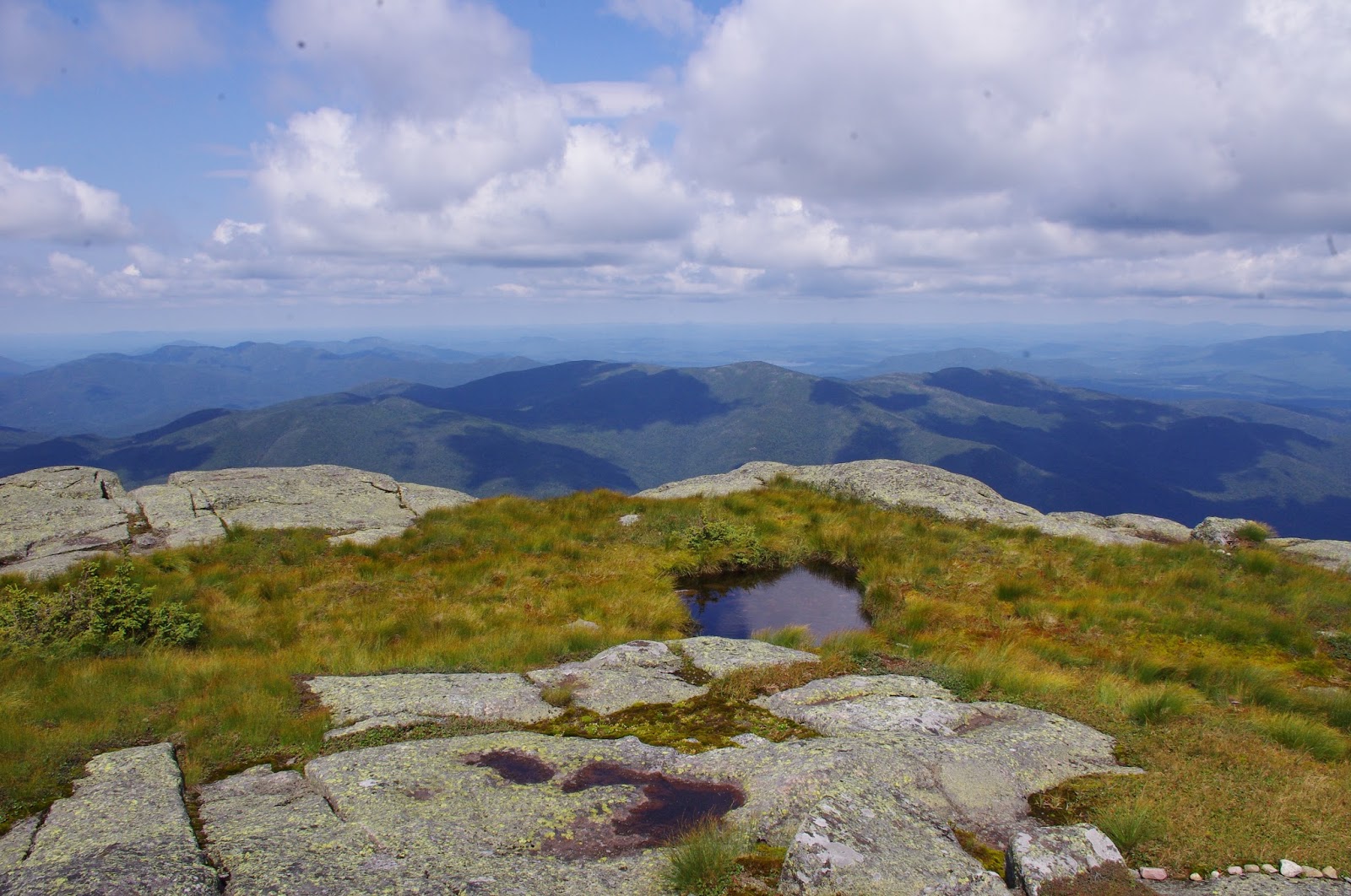
Once past the dam the trail begins to climb at a steady but easy grade all the way to the treeline of Marcy's summit. The path was surrounded by snow-covered trees, which gradually became shorter in height and more thickly covered in snow and ice. Just before Indian Falls the call of a Boreal Chickadee, which was curious enough to come check me out, was proof that I wasn't too far from the alpine zone. From Indian Falls to Marcy's shoulder the path was wide and covered in 2-3 feet of packed snow, perfect for snowshoes. After 5.5 miles, about 1.5 miles from the summit, Marcy finally comes into view on the right, looming above a mile-long swath of snow-covered balsams. Shortly after that the balsams become more sparse and for the last half mile across the ridge there are incredible views of Haystack to the southeast and the McIntyre range to the north. On this particular day, however, clouds had come rolling in to obscure views to the north, but there was still an amazing view to the south and east. The steep, rocky summit of Haystack looms nearby as the closest neighbor, beckoning me to climb it next. Further beyond I could see the Great Range, though the tips of each peak were covered by a sheet of low-lying clouds. I was fearful that the clouds would roll in and obscure the view completely, but they remained to the north while I was there. There is something eerie and almost frightening about being so exposed on a bare summit in a sea of clouds, as if they could swallow you whole. There is some reason to be afraid, as clouds can also bring blinding snow, and on a broad summit like Marcy white-out conditions can become quite dangerous (last year a man was forced to camp on the summit for a night after becoming lost in a white-out, fortunately he had the skills and gear to survive). A few hundred feet from the summit the trees disappear and the trail becomes a scramble over rock and ice, and here I have to admit that I didn't make it all the way to Marcy's true summit. About 100 feet below I encountered some icy patches that I knew my snowshoes would not be able to grip, and I had left my crampons in the car. While I probably could have ascended the icy pitch without any problems I was reluctant to do so alone, as I wasn't sure if any other hikers were behind me. When hiking alone I tend to be very cautious, and though it sounds crazy to most people, it didn't really matter to me if I made it to the top, especially when most of the view was obscured by clouds. So I walked back down a few hundred feet to a less-exposed area and enjoyed my lunch in the alpine zone surrounded by plants concealed by snow and ice rime, looking out at the gorgeous view of Haystack and the dozens of peaks beyond it.

Being in the alpine zone of Mt Marcy is worth all the effort


Even though Marcy is an easier hike than many other high peaks, it is still far from easy. Reaching the summit (or near it, in my case) still requires ascending over 3000 feet in 7 miles, and is exhausting. But what's more exhausting is hiking 7 MORE miles after that to return to the car. Of course hiking up and hiking down are very different beasts--on the way up you have the option of giving up, but on the way down you have no choice but to just keep moving, no matter how much your body doesn't want to. For me exhaustion usually sets in after about 10 miles, and pain after about 12. Due to an excruciating blister on my right heel the pain and exhaustion both set in at about 10 miles, making for a long hike back to the car. Fortunately I began keeping pace with some nice retirees from Rochester for a couple of those miles, and their conversation helped take my mind of the pain. But I lost them when I stopped at Marcy Dam to feed the chickadees again, which had grown ten-fold in number and kept me occupied for much longer this time. In fact the chickadees were quite entertaining this time, having numerous squabbles over the almond in my hand and often landing two at a time to take them. I could have sat there are fed them all day, but the last two miles were haunting me and I wanted them to be over. The last two miles between the dam and the Loj are my least favorite part of the entire Adirondack Park, as it is a relentless stretch of ascents and descents, culminating in one final climb to the parking area that uses every bit of energy you have left in your exhausted and pain-ridden body. Those two miles seem like so much longer, but somehow I always make it to the lot just when I think I can't take another step, and collapse in the car.


Sculpted snow in the krummhotlz zone
Even though I didn't make it all the way to the top the climb up Marcy was well worth the effort. There is something so awe-inspiring about being higher than any other mountain, it's more like being in the sky than like being on land when the clouds are below you and you're looking down at everything you know. And I find so much to admire in the krummholz zone (where the balsams become shorter and eventually give way to bare rock), like the way the snow becomes sculpted by the wind as it clings to branches, or turns to crystals on the rocks, or twists and turns with the wind-driven branches of the balsam firs. To me the krummholz zone is so surreal that it's more exciting than the bare rock summit, and was the perfect destination for me.


The Great Range in the distance