The first time I climbed Algonquin was back in 2007, nearly five years ago when I first started hiking the high peaks. I was very much looking forward to exploring the broad summit, soaking in the views of more than 100 peaks, but the weather had other ideas. Although it was a fairly warm day at the bottom, at the top the winds were so fierce that I had to hold onto all by belongings to keep them from flying off the mountain, and even had to brace myself to keep from falling over. I stayed on the summit just long enough to snap some pictures and then descended to the Wright trail junction to eat and log the hike into my journal. But I always knew I would return to the mountain someday in a quest to climb Iroquois, for the which the shortest route is to take the trail from the Loj to Algonquin and continue onto Boundary and Iroquois. I made sure I waited for a better day this time so that I could enjoy the summit, and the weather turned out to be absolutely perfect.
 |
| Alpine grasses and sedges create lush meadows |
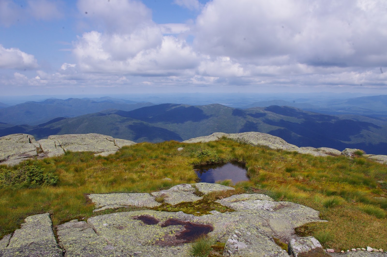
The main reason I was looking so forward to climbing Algonquin is because its height (the second highest at 5,114 feet) and broad summit make it the perfect habitat for alpine species of plants. Many of the Adirondack high peaks have plants that are found only in alpine habitats, but none of them have as much alpine vegetation as Algonquin. There are only 85 acres of alpine habitat in the Adirondacks, and more than half of that is found on the McIntyre range, which is the collective term for the ridgeline that is composed of Algonquin, Boundary, and Iroquois peaks. The trail to Algonquin from the Loj is only 3.6 miles, but with an ascent of nearly 3,000 feet it is a very steep, relentlessly rocky hike to the summit. A few hundred feet below the summit the trees give way to open rock and the largest alpine meadow I've seen in the Adirondacks. It looks like a sea of grass (sedge actually), the way the Deer's Hair Sedge flows in the wind. Upon closer inspection one can find alpine species of wildflowers, lichens, and shrubs. On one part of the summit a puddle of water nestled in the sedge meadow made a beautiful foreground for photos of the surrounding peaks. Algonquin is a very popular trail, we probably saw a couple dozen other hikers just in the time that we spent on the summit, but there is room on the summit for everyone to have their own space. To protect the fragile alpine vegetation from so many hikers small rocks have been put in place to keep people on the bare rock, and furthermore a summit steward is present to educate people on the importance of preserving the rare alpine plants. Alpine plants need to have very shallow root systems in order to grow in such a thin layer of soil, which makes them very vulnerable to the pressure of people's footsteps. Heavy traffic in the 1970's ruined a great deal of alpine vegetation in the Adirondacks, but conservation and education efforts to keep people off the soil have been effective in restoring the alpine character of the Adirondack high peaks so that people like me can enjoy it today.
 |
| The alpine ecosystem of Algonquin's summit |
 |
| Boundary and Iroquois from Algonquin |
This McIntyre range is one of the most distinctive ridgelines in the Adirondacks, as thousands of people glance at it each day as they pass the Loj Road on route 73. I look at it almost every day, and can't count the number of sunrises and sunsets I've seen painting the ridge in color. Just last week I had a closer view of it from the summit of Colden, which is separated from the McIntyre Range by the steep walls of Avalanche Pass. From Colden the traverse from Algonquin to Boundary and Iroquois, so named because Boundary
was once the landmark that separated hunting grounds between the Algonquin and Iroquois tribes, looked like it would be an easy one. It looks like there is minimal elevation gain between the two peaks, as you simply descend Algonquin, hike over the small bump that is Boundary, and then scramble up a few hundred feet to the summit of Iroquois. What you don't see from the summit of Colden is the two steep sections of bare rock that you have to climb hand-over-foot in order to reach the summit. The walk over the ridgeline is very pleasant, the trail is so narrow that you feel as though you're being embraced by the balsam fir, and you have to brush up against other people to pass them on the trail. A new series of wooden planks, just built this year, carries you over the muddy sections of the cols between the peaks, and gives your feet respite from the rocks and mud. You break out of the balsams for just a moment to reach the bare rock bump of boundary, then dip back down into them to make your way toward Iroquois. The last tenth of a mile to Iroquois is more challenging than I expected, and the last ten feet is the worst. There is one large rock at the edge of the summit, the last step before the destination, that I had a tough time mustering up the courage to leap up, but fortunately was saved by a nice person on the summit that came to give us a hand. The summit of Iroquois doesn't have glorious alpine meadows like Algonquin, but it does have peace and quiet, as only a handful of people that climb Algonquin continue onto Iroquois. The view is just as amazing, looking down at Lake Colden and Flowed lands, and peering further to the peaks of the south and west than Algonquin. We didn't stay long, though, because we knew the hardest part of the hike was yet to come.
 |
| View from Algonquin to the west |
Hiking down from Iroquois was a mental challenge, and hiking back up over the summit of Algonquin was a physical challenge. That was the first point in the day where my legs just refused to keep going, and we had to rest a few times while making that last ascent to Algonquin's summit. Once we reached the top we collapsed and stayed to enjoy the summit for a long time. The weather was mostly sunny with only a light breeze, which is an uncommonly perfect day to be on Algonquin. I stripped off my shoes and socks, ditched the windbreaker, and laid my head back on my pack to relax. For a while I just laid there watching the Deer's Hair Sedge flow with the breeze, gazing at the striking slides of Colden beyond. I didn't ever want to leave, but I knew it wouldn't stay 70 and sunny for too much longer. The hike back seemed longer than the hike in, and took us just as much time, almost 3 hours. Navigating the rocky terrain of Algonquin's trail for the next 2.5 miles was very slow going, and even as slow as we were going my hiking partner slipped a few times. We were relieved to finally reach the main trail back to the Loj, relishing the soft dirt for the past mile. We were completely exhausted, but exhilarated to have completed the hike.
 |
| View from Algonquin to the east, with Mt. Colden prominent in the center |
 |
| Algonquin's alpine summit |
As I hiked I couldn't help thinking about what life was like in the time of the tribes that those two peaks are named for, how much more difficult it must have been to climb those peaks before trails. Did they take the same route that we had taken, or did they know an easier way? So many of the Adirondack mountains had been named by the tribes but were later renamed for famous settlers and explorers. I think Tahawus, meaning "cloudsplitter" is a much better name than Mt. Marcy and wish it had stayed that way. It's little consolation that people had the sense to at least recognize the significance of the peaks to native tribes by choosing to name two of the giants "Algonquin" and "Iroquois", but at least in doing so they've retained a small part of the region's pre-settlement history. I wonder how often the native tribes climbed such mountains, whether they did so to hunt game and gather fruit, like the cranberries I saw growing on Boundary, or if they, like me, just climbed it for sheer enjoyment, to gaze at all the peaks below and remind themselves of how magnificent the Adirondacks truly are.


No comments:
Post a Comment